Pages
▼
Saturday, 17 December 2011
Thursday, 15 December 2011
Binsar Mahadev
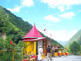
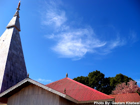
Binsar Mahadev is situated in between the deodar and pine trees. Binsar Mahadev is a big mandir with large premises. Binsar Mahadev is 19 km from Ranikhet. There's another old Binsar Mahadev at Binsar near Almora.
Also small children who want to become pandit stay and learn here. A guru and his shishya.
Also small children who want to become pandit stay and learn here. A guru and his shishya.
Wednesday, 14 December 2011
Hat Kalika Mandir
Hat Kalika temple is situated amidst deodar forests, the Janhavi Naula (a covered spring). See more
Tuesday, 13 December 2011
Kaichi Dham
17 Kms from Nainital is this Kaichi Dham. This is ashram of the famous Neem Karoli Maharaj. Kaichi is a term used for two sharp hairpin bends of the motor road seen here. There is enough wide road in front of this temple with shops around. Temple premises are full white, neat and vibrant with various different rooms in which photos and idols of the Maharaj are kept. See more information
Wednesday, 7 December 2011
Ranikhet
Asia's Highest Golf Ground, Ranikhet Golf Ground. One can rest here if the sports are not on. Just ahead of this Ranikhet Golf Course is the Upat Kalika Mandir.
Narsingh Ground, Ranikhet where all the school children play here and also physical trainings are conducted here.
Police Bungalow, Spring Field, Ranikhet. When some officers get post here, they come into the police bungalow for resting. The photo is of the garden in front of Police Bungalow, Springfield.
Rani Jheel is a small jheel 1 km from main road. Rani Jheel stores some water. One can have a nice walk around this Jheel.
A vulture perched on a high tree branch in Ranikhet. There are Egyptian Vultures flying in high altitudes here.
Narsingh Ground, Ranikhet where all the school children play here and also physical trainings are conducted here.
Police Bungalow, Spring Field, Ranikhet. When some officers get post here, they come into the police bungalow for resting. The photo is of the garden in front of Police Bungalow, Springfield.
Rani Jheel is a small jheel 1 km from main road. Rani Jheel stores some water. One can have a nice walk around this Jheel.
Jungles in Ranikhet are dense. This is one of the photo of the Jungle where sunlight is streaming down to a bunch of orange flowers.
Upat Kalika Mandir is near the Golf Ground
Army on their training schedule in Ranikhet
Shawl and Tweed Factory in Ranikhet near Narsingh Ground. It was a church before being converted into a factory.A vulture perched on a high tree branch in Ranikhet. There are Egyptian Vultures flying in high altitudes here.
Saturday, 26 November 2011
Chiliyanaula
Mount Trishul, Mrigthuni, Nanda Devi, Nanda Kot, all the high mountain ranges as seen from Chiliyanaula.
Mount Trishul and Mrigthuni from the bell view.
Haidakhan Mandir at Chiliyanaula. Hairakhan Temple which war established by Shri Hairakhan Maharaj who is said to be incarnation of lord Shiva.
Nandi Bail starring Haidakhan Mandir in front of beautiful trees.
Kumaon mountain range seen from Chiliyanaula with various names of mountain inscribed on concrete circle.Wednesday, 9 November 2011
Steps Farms of Uttarakhand
Step farming are done majority in Uttarakhand. Step farming is done because there are mountains unlike plains. In plains area is big and you can use big tractors too whereas in mountains you have to make steps like farm according to slope and you can only use ox to plough. These farms when ripe look very beautiful and colourful in clusters. This one is near Bageshwar taken at Karuli.
This was beautiful stepped farms with village on top and nice skies on back. This was taken near Pithoragarh.
This was another stepped farms mostly barren as can be seen. Clusters of vegetation had grown without anything growing on the farm. This was taken while going to Pancheshwar, Lohaghat.
This was beautiful stepped farms with village on top and nice skies on back. This was taken near Pithoragarh.
This was another stepped farms mostly barren as can be seen. Clusters of vegetation had grown without anything growing on the farm. This was taken while going to Pancheshwar, Lohaghat.
Below is a photo of step farm in Didihat.
Monday, 7 November 2011
Jauljibi
Jauljibi is a small town in Pithoragarh District where there is sangam of Gori and Kali River. This town lies near the natural border of India and Nepal. After this Dharchula lies from which people go to Kailash Mansarovar Yatra.
Jauljibi bridge connecting India and Nepal.


